Feral Jundi

Thursday, September 6, 2012

Mobile Apps: The Tactical Radio Mobile App?

This is one of those posts where I thought, why hasn’t anyone in the tactical industry or law enforcement industry developed a mobile app that can convert your smart phone into a 2 way radio? Because according to this article, private industry has already created three mobile apps that turn your phone into a basic 2 way radio.

So for this post, the idea is basic. Create a similar 2 way radio mobile app, but ‘tactify’ it. lol Get it encrypted and secure, and give it functions that would be applicable to military/police/contractor uses. Or just have basic switches on the mobile app that allow a user to customize the app to suite their needs.

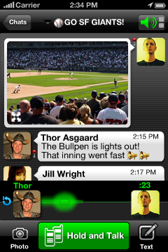
The top mobile app for turning your smart phone into a basic 2 way radio according to this article below is Voxer Walkie-Talkie. If you would like to play around with it, and maybe use it for hunting or none tactical purposes, here is a link to check it out. Here it is on iTunes, and below is the description of what it does.

Description
Featured by Apple in 50+ countries
Turn your phone into a Walkie Talkie.
Don’t waste time on phone calls and voicemails.
Voxer® is a Walkie Talkie app for smartphones. Send instant Audio, Text, Photo and Location messages to one friend or a group of your friends. Your friends can listen to your message while you talk or check it out later.
-LIVE WALKIE TALKIE
-Cross Platform Messenger
-VOICE, TEXT, PHOTOS and LOCATION
-GROUP CHATS
-EVERYTHING is FREE
-No annoying advertisements
-Works over WiFi, 3G and any other data network
-Get notifications for new messages
-Create messages even offline
-Play voice messages faster
-Connect with Facebook friends on Voxer
Voxer turns your iPhone/iPad/iPod touch device into the ultimate Push To Talk (PTT) real-time Walkie Talkie.

The other thing I was thinking about with a Tactical Radio Mobile App is that companies could save money by not having to buy expensive handheld two way radios. They could just depend upon an internet connection locally or 3G/data networks, and have a team work off of that. So instead of depending upon a repeater, you are depending upon a diversified array of ‘repeaters’. Or you could have this as your back up to your pre-existing communications system.

Another angle is to create a Garmin Rhino style mobile app. Something that turns your smart phone into a basic Garmin Rhino, complete with blue force tracker style capability and two way radio functionality.

On the downside would be battery life. So along with the mobile app, you would probably have to get hardened cases with extra battery juice installed, to further extend the radio’s life and durability through a shift. Although I think the market has plenty of sources for this type of thing. I would think a power source that would give your phone enough juice to last a 12 hour shift would be acceptable. Rechargeable would be necessary as well. Pretty neat and I hope someone out there is able to take this idea and run with it. Maybe do a kickstarter for it? –Matt


Smartphone? Presto! 2-Way Radio
By DAVID POGUE
September 5, 2012
Cave drawings, smoke signals, letters, Pony Express, telegrams, phone calls, text messages. From the dawn of civilization, man has experimented with different modes of communication, each with pros and cons. Smoke signals, for example, contribute to far fewer car accidents than text messages. Text messages, on the other hand, leave much less soot.
You might think that we’ve exhausted every variation on electronic communication — text, audio, video — but you’d be wrong. A new one is quietly winning over millions of gadget fans. They’re free apps with names like Voxer, HeyTell and Zello, and they really do mess with the rules of the game.
Nobody’s settled on a good name for this communications category. But if we call them voice-texting apps, or walkie-talkie apps, you’ll get the idea.
They work on iPhones, iPads, iPod Touches, Android phones and Windows phones. You open the app, tap someone’s name, hold down the big Talk button and speak. A second after you start talking — yes, even before you’re finished — your voice bursts to life, extremely clearly, on your friend’s phone, wherever it may be in the world.
Your buddy can respond to you by pressing his own Talk button, and the conversation is under way.
Now, before you roll your eyes — “These youngsters today! Why do they need so many different ways to talk!?” — consider all the ways these apps improve on existing modes of chat.

(more…)

Monday, August 20, 2012

Mobile Apps: Theodolite–Turning Your Smart Phone Into A Precision Survey Instrument

Filed under: Mobile Apps,Technology — Tags: , , , , , — Matt @ 10:49 AM

Now this is cool and a big hat tip to Soldier Systems for putting this one out there. This mobile app basically converts your smart phone into an actual theodolite or surveying instrument.  Why is this cool? Because this device not only has application for cheap and quick surveying of land, but can also help in military operations where surveying, targeting, and reconnaissance is vital.

The other thing I was thinking about here is something like this could quickly help land owners settle disputes over boundaries. So instead of hiring a survey group to do this, two parties can just pull out their smart phones and confirm together where the boundary is between their properties. In the west where folks have all sorts of surveying assets to call upon, this is not too big of a problem. Although I could still see folks using such a thing to confirm or use as a preliminary survey tool.

But in poor countries with minimal resources, having an ability to determine borders and boundaries cheaply can mean the difference between life and death.  Many wars and conflict start because of boundary disputes between two parties. Especially in places with very weak legal systems, or non-existent legal systems.

The other thing I was thinking about here is the ability to take an app like this and download it into a ‘smart scope’. Or basically take an optic like an EOTech and design it so that it can put this data in the view if you want it–and all with the press of a button. Or you could cycle through your reticles for whatever application (like grenade launcher, machine gun, etc.). Anything that helps the soldier with targeting and making the optic useful.

I also like the idea of using this tool to help in setting up a remote site or combat outpost/FOB. From lining out the Hesco barriers, to setting up defensive positions and fire plan sketches–having a survey tool like the Theodolite mobile app is incredibly useful. –Matt


Theodolite is a multi-function augmented reality app that combines a compass, GPS, map, photo/movie camera, rangefinder, and two-axis inclinometer. Theodolite overlays real time information about position, altitude, bearing, range, and inclination on the iPhone’s live camera image, like an electronic viewfinder.??Uses are endless, and Theodolite is great for outdoor sports, hiking, boating, hunting, golf, sightseeing, photography, and navigation. The app is used in the field every day by surveyors, geologists, architects, engineers, military personnel, competitive sportsmen, and search and rescue workers.??Theodolite set a new standard for augmented reality navigation apps when it debuted in 2009. It has been featured numerous times in iTunes (including honors as a “Rewind 2010” app), and has been the #1 selling Navigation app in iTunes stores around the world.

Theodolite works on any iPhone or 4th generation iPod Touch with OS 4.1 or later.?Compass requires iPhone 3GS, 4, or 4S. iPhone 4 or 4S, or iPod Touch 4 required for gyro and Retina Display support.
Features
Ability to take geo-stamped and geo-tagged photos, screenshots, and movies from the app, with 2X and 4X zoom, buffered background image saves, plus an option to write custom notes on photos and movies. Integrated map with standard, satellite, and hybrid views, compass rose, and bearings. Manage location markers on the map and share with other users via SMS text messaging or e-mail. Optical-mechanical gyro/accelerometer calibration. Zero angle reference mode. A-B survey calculator for height, distance, heading, triangulation, position, and angles. Data logging. E-mail data export with KML. System-wide clipboard integration. Percent grade display. Six different optical rangefinders. Mils. Night vision lens filters. MGRS, UTM, and six lat/lon formats.For use on an iPad, check out Theodolite HD.

What’s New in Version 3.0
NEW! Movie recording, with optional screen/watermark overlays and multiple video quality settings. Three large-format stadiametric rangefinders (sniper/artillery/hunter style, showing distance multipliers, yards, or meters). Revised position formats with new decimal minutes option. Larger font sizing for photo data stamp watermark, with three color options. Onscreen indicator for magnetic declination errors. Bug fix to e-mail export URLs. Numerous performance improvements and tweaks.
Website here.
Purchase at iTunes here.


Thursday, July 21, 2011

Mobile Apps: Tactical NAV Smartphone App Directs UAV–Thwarts Taliban Attack

Filed under: Afghanistan,Mobile Apps — Tags: , , , , — Matt @ 9:07 AM

Excellent little story, although I would like to hear it from the security contractors involved. There is no mention of the company either. So whomever was involved, if you would like to confirm this here on the blog or talk to me in private, I can make the edits to show this actually happened.

The concept of the app is great and it would be nice to get some more details about this incident. Like how the contractor found out about the Tac NAV, and did it work as advertised? It sounded like he was able to communicate the needed information for this incident, and get a UAV over the attacking force.

On the other hand though, did the Taliban run because of the UAV, or were they only conducting a ‘hit and run’ attack and they happened to be gone when the UAV arrived on scene? That is why I would like to get a little more detail before cheering this mobile app on.

Cool stuff though, and if you have a smartphone this would be a good mobile app to have, just because it doesn’t weigh anything and you can store it indefinitely on your phone. –Matt

Tactical NAV Smartphone App Directs UAV – Thwarts Taliban Attack
Jul 21, 2011
Kabul, Afghanistan – With the number of private military contractors exceeding the number of troops on the ground in both Iraq and Afghanistan, a growing concern for keeping contractors safe is more pressing than ever. ?On June 28, a private contractor located near Kabul came under insurgent fire while located in an area where he and his American contractors were working. The contractor immediately called the International Security Assistance Force (ISAF) tactical operations center (TOC) for military support, and ISAF personnel then quickly responded by requesting the military grid reference system (MGRS) grid coordinates to the insurgent threat.?However, the contractor was not equipped with a military GPS device or a 1:50,000-scale map to give the proper MGRS coordinates to the TOC. Instead, the contractor used Tactical NAV on his iPhone, and was able to quickly and accurately provide the assisting military personnel with his location, and also the location where the insurgent fire was coming from. As a result, an unmanned aerial vehicle (UAV) was dispatched to survey the perimeter of the base, and the insurgent attack was thwarted.?Developed for Soldiers by Soldiers, Tactical NAV assists troops in mapping, plotting and photographing waypoints on the battlefield and also helps Soldiers convey coordinates to other supporting units. Tactical NAV incorporates a compass, camera and a gridded map reference system to accurately pinpoint specific locations and relay that information to other users.

Device Requirements:-iPhone, iPod touch, and iPad-Requires iOS 4.2 or later-5.9
Story here.

Thursday, January 27, 2011

Technology: Soldier Develops Smartphone App To Track Taliban

     This is pretty cool. Although the real test is if the guys out in the field will actually use this in combat? But the idea of how this guy dreamed it up and put his heart and soul into the project to get it out there is really inspirational.

     With that said, with a quick search you can find several programers out there that will build apps for a price. If you have an idea and have the 15,000 to 20,000 dollars to contract out the project, then maybe you too could come up with a life saving app, or even an enemy killing app that could give military or contractors the edge out there. No word yet on when the app will be available in iTunes, nor do I know the cost.-Matt

Soldier develops Smartphone app to track Taliban: Tactical Nav can pinpoint enemy and direct fire

By Paul Thompson27th January 2011

An iPhone app that tracks down the Taliban has been developed by a US soldier who used pds 17,000  of his own money into the project.

Captain Jonathan J. Springer said the idea for a Smartphone app to help soldiers in combat came to him in a dream last July.

The 31-year-old, from Fort Wayne, Indiana, has worked with programmers ever since to make the idea a reality.

Smart idea: Captain Springer (pictured here testing his invention in Afghanistan) used a variety of armoured vehicles, remote observation posts and harsh combat conditions to test the accuracy of his invention

Tactical Nav, which is expected to be available through Apple’s App Store next month, assists soldiers in mapping, plotting and photographing waypoints on a battleground and conveying coordinates to supporting units.

Captain Springer used a variety of armoured vehicles, remote observation posts and harsh combat conditions to test the accuracy of his invention, which can also be used to direct artillery fire on enemy positions or call in helicopter support.

The soldier, who serves as a battalion fire support officer in eastern Afghanistan, said most soldiers use smartphones and the app has been designed specifically for them. (more…)

Powered by WordPress